1) Download MS4W . This is a package which bundles Mapserver with PHP and Apache. Saves time on configuration. I set the Apache port to 81, since I already have another version running on 80. The default location of all installed files is c:/ms4w.
2) Installed Quantum GIS. Again you can use another bundled package which includes geoserver and many other open source tools. Alternatively you can get the software direct.
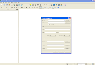
3) Quantum GIS contains a nifty plug in for generating .map or mapfiles for Mapserver (the alternative is to write them by hand which can be a major pain). This can be done via the plugin menu option. Once installed, this is the plug in window:

Two things to remember. First, create an empty .map file in your favourite text editor. In the plug in interface, you need to point to an existing .map file. The Quantum plug in will overwrite this file. Second, I found it easier to put the .map file and shapefiles (at least for this initial trial) in the same directory.
You should now have a working mapfile. Now for WMS. You will need to edit the generated mapfile to add additional parameters. This and the required url parameters are a pain. After much searching I found these two links very useful:
http://www.mapserver.org/ogc/wms_server.html#table-of-contents
http://ms.gis.umn.edu:8081/ms_plone/docs/howto/mapcontext
I'll not walk too much through the additions, but they mostly involve adding elements under the METADATA tag. Here is my working mapfile:
# Map file created from QGIS project file C:/matts/generatefile/test.qgs
# Edit this file to customize for your map interface
# (Created with PyQgis MapServer Export plugin)
MAP
NAME test
# Map image size
SIZE 400 300
#UNITS meters
EXTENT -97.616877 39.917875 -81.745000 51.087523
PROJECTION
'proj=longlat'
'ellps=WGS84'
'datum=WGS84'
'no_defs'
''
END
# Background color for the map canvas -- change as desired
# IMAGECOLOR 192 192 192
#IMAGEQUALITY 95
IMAGETYPE png
OUTPUTFORMAT
NAME png
DRIVER "GD/PNG"
MIMETYPE "image/png"
IMAGEMODE RGB
EXTENSION "png"
FORMATOPTION "INTERLACE=OFF"
END
# Legend
LEGEND
IMAGECOLOR 255 255 255
STATUS ON
KEYSIZE 18 12
LABEL
TYPE BITMAP
SIZE MEDIUM
COLOR 0 0 89
END
END
# Web interface definition. Only the template parameter
# is required to display a map. See MapServer documentation
WEB
# Set IMAGEPATH to the path where MapServer should
# write its output.
IMAGEPATH '/tmp/'
# Set IMAGEURL to the url that points to IMAGEPATH
# as defined in your web server configuration
IMAGEURL 'http://localhost:81/wms_mapserver/tmp'
# WMS server settings
METADATA
'wms_title' 'test'
'wms_onlineresource' 'http://localhost:81/cgi-bin/mapserv.exe?map=C:/ms4w/Apache/htdocs/wms_mapserver/data/ms_wms.map&'
'wms_srs' 'EPSG:4326'
"wms_extent" "201621.496941 -294488.285333 1425518.020722 498254.511514"
#"wfs_title" "test WFS Demo Server" ## REQUIRED
END
#Scale range at which web interface will operate
# Template and header/footer settings
# Only the template parameter is required to display a map. See MapServer documentation
END
LAYER
NAME 'states_ugl'
TYPE POLYGON
DATA 'C:/ms4w/Apache/htdocs/wms_mapserver/data/states_ugl.shp'
METADATA
"wms_name" "states"
"wms_server_version" "1.1.1"
"wms_format" "image/png"
"wms_srs" "EPSG:4326"
"wms_title" "States" ##required
"wms_extent" "201621.496941 -294488.285333 1425518.020722 498254.511514"
"wms_onlineresource" "http://localhost:81/cgi-bin/mapserv.exe?map=C:/ms4w/Apache/htdocs/wms_mapserver/data/ms_wms.map?"
#"wfs_version" "1.1.0"
# "wfs_srs" "EPSG:4326"
# "wfs_typename" "statefs"
# "wfs_request_method" "GET"
# "wfs_service" "WFS"
#"wfs_title" "statefs" ## REQUIRED
#"gml_featureid" "ID" ## REQUIRED
#"gml_include_items" "all" ## Optional (serves all attributes for layer)
END
#CONNECTIONTYPE WMS
STATUS ON
TRANSPARENCY 100
PROJECTION
'proj=longlat'
'ellps=WGS84'
'datum=WGS84'
'no_defs'
''
END
CLASS
NAME 'states_ugl'
STYLE
SYMBOL 0
SIZE 2
OUTLINECOLOR 0 0 0
COLOR 144 50 207
END
END
END
END
As you can see this sits in the following directory with my shapefile:
C:/ms4w/Apache/htdocs/wms_mapserver/data
I did my testing using Internet Explorer. As mentioned, the required url parameters are a pain. Here are the two key calls; getCapabilities:
http://localhost:81/cgi-bin/mapserv.exe?map=/ms4w/Apache/htdocs/wms_mapserver/data/ms_wms.map&SERVICE=WMS&VERSION=1.1.1&REQUEST=GetCapabilities
and getMap. Note all parameters except styles are required:
http://localhost:81/cgi-bin/mapserv.exe?map=/ms4w/Apache/htdocs/wms_mapserver/data/ms_wms.map&service=WMS&version=1.1.1&request=GetMap&layers=states_ugl&srs=EPSG:4326&bbox=-97.6169,39.9179,-81.745,51.0875&format=image/png&width=400&height=300&styles=default
I struggled for a while on the getMap call. One problem I realised was the BBox parameters you need to get from getCapabilities (I grabbed it directly from the mapfile). I also initially added connectiontype "wms" for the layer in the mapfile which broke everything - actually i could not generate an image. As soon as that was removed bingo.
Grab this source, unrar and place in your C:/ms4w/Apache/htdocs. You should now be able to run the above.
1 comment:
404 for the source, mate
Post a Comment